Indian States, Capitals and Population (Census 2011)
The 28 states and 8 union territories with their capitals, how the states were formed, the Census 2011 numbers exams ask, and India's neighbours and borders.
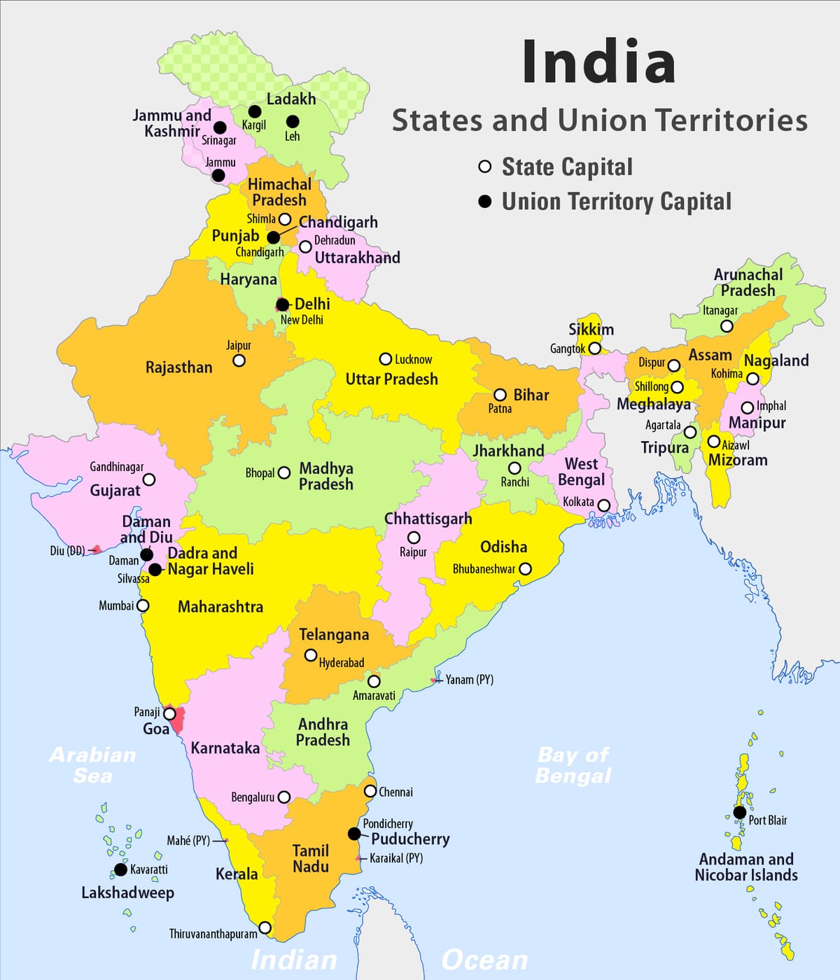
States and union territories of India. White circles are state capitals; black dots are UT capitals. This map shows the new UTs Jammu & Kashmir and Ladakh (2019). It was drawn before 26 January 2020, so it still shows Dadra & Nagar Haveli and Daman & Diu as two UTs — they are now one UT. Image: Maximilian Dörrbecker (Chumwa), Wikimedia Commons · CC BY-SA 2.5
India is a union of 28 states and 8 union territories (UTs). A state has its own elected government. A UT is run mainly by the Centre through an administrator. Exams ask capitals, the year each state was formed, the Census 2011 numbers, and which states touch which neighbouring country.
On this page you will learn:
All 28 states and 8 UTs with their capitals
How the states were formed, from 1953 to 2020
Largest and smallest states by area and population
Census 2011: density, sex ratio, literacy and religion
How India's population grew, and birth and death rates
India's neighbours, border lengths and border states
28
States
Since 31 October 2019
8
Union territories
Since 26 January 2020
121.09 crore
People, Census 2011
About 17.5% of the world on 2.4% of its land
States and their capitals
Rule in one line: learn the capital with the state, and learn the odd ones — shared, new or seasonal capitals.
State
Capital
Andhra Pradesh
Amaravati (declared; still being built)
Arunachal Pradesh
Itanagar
Assam
Dispur
Bihar
Patna
Chhattisgarh
Raipur
Goa
Panaji
Gujarat
Gandhinagar
Haryana
Chandigarh
Himachal Pradesh
Shimla
Jharkhand
Ranchi
Karnataka
Bengaluru
Kerala
Thiruvananthapuram
Madhya Pradesh
Bhopal
Maharashtra
Mumbai
Manipur
Imphal
Meghalaya
Shillong
Mizoram
Aizawl
Nagaland
Kohima
Odisha
Bhubaneswar
Punjab
Chandigarh
Rajasthan
Jaipur
Sikkim
Gangtok
Tamil Nadu
Chennai
Telangana
Hyderabad
Tripura
Agartala
Uttar Pradesh
Lucknow
Uttarakhand
Dehradun
West Bengal
Kolkata
The 28 states in A–Z order. Chandigarh is the shared capital of Punjab and Haryana, and is itself a UT.
ANDHRA PRADESH'S CAPITAL
When Telangana was carved out in 2014, Hyderabad went to Telangana. It stayed the shared capital of both states for ten years, until June 2024. Andhra Pradesh has declared Amaravati its capital; the city is still being built. If an old question offers Hyderabad for Andhra Pradesh, read the year of the paper.
Union territory
Capital
Remember
Andaman & Nicobar Islands
Sri Vijaya Puram (old name Port Blair)
Renamed in 2024
Chandigarh
Chandigarh
UT since 1966; capital of Punjab and Haryana
Dadra & Nagar Haveli and Daman & Diu
Daman
Two UTs merged, 2020
Delhi (NCT)
New Delhi
Has its own legislature
Jammu & Kashmir
Srinagar (summer), Jammu (winter)
UT with legislature since 2019
Ladakh
Leh
Largest UT by area; no legislature
Lakshadweep
Kavaratti
Smallest UT; 36 coral islands
Puducherry
Puducherry
Has a legislature; four separate parts
The 8 UTs. Three have their own legislature: Delhi, Puducherry and Jammu & Kashmir.
Two famous UT capitals
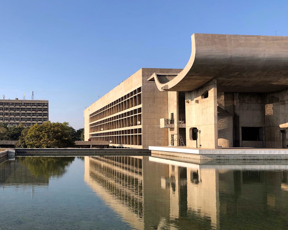
Palace of Assembly, Capitol Complex, Chandigarh — designed by Le Corbusier. The city is named after the Chandi Mandir temple; 'garh' means fort.
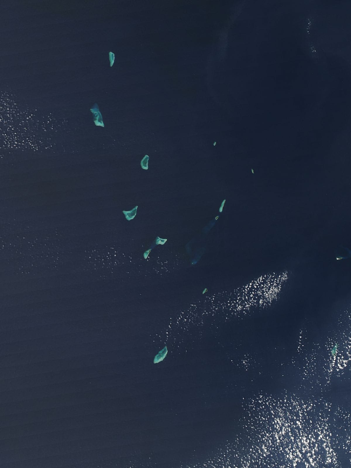
ImageLakshadweep from space (NASA, 2015): coral islands and reefs in the Arabian Sea off Kerala. It is a group of 36 islands — India's smallest UT. Its capital is Kavaratti. Malayalam is widely spoken here, as in Kerala. Image: Jeff Schmaltz, MODIS Land Rapid Response Team, NASA GSFC, Wikimedia Commons · Public domain
QUICK CHECK
PYQ · Punjab Police SI 2023 — What is the capital of Lakshadweep?
Tap an option to answer
Answer: C — Kavaratti
Kavaratti is the capital. Minicoy, Agatti and Kadmat are other Lakshadweep islands. SI 2016 asked the same; there Port Blair was the trap.
QUICK CHECK
PYQ · PPSC ACE 2021 — Which one of the following islands is not a part of Andaman and Nicobar Islands?
Tap an option to answer
Answer: C — Kavaratti
Kavaratti is in Lakshadweep, in the Arabian Sea. Long Island, Narcondam and Havelock are in the Andaman Sea / Bay of Bengal.
QUICK CHECK
PYQ · Punjab Police SI 2023 — Which of the following derives its name from the temple of 'Chandi Mandir' and was planned by Le Corbusier?
Tap an option to answer
Answer: A — Chandigarh
Chandigarh: named after Chandi Mandir near Panchkula, and planned by the architect Le Corbusier in the 1950s.
How the states were formed
Rule in one line: in 1956 states were redrawn by language; later ones were carved out for regions and tribes.
FORMATION OF STATES: THE DATES THAT ARE ASKED
1953
Andhra State
1 October 1953: the first state made on the basis of language (Telugu).
1956
States Reorganisation Act
1 November 1956: India redrawn into 14 states and 6 UTs, mostly by language. Kerala and the united Andhra Pradesh (with Telangana) were formed.
1960
Maharashtra and Gujarat
1 May 1960: Bombay State split into two.
1963
Nagaland
1 December 1963: carved out of Assam.
1966
Punjab reorganised: Haryana
1 November 1966: Haryana formed; hill areas went to Himachal; Chandigarh became a UT.
1971–72
Himachal, Manipur, Tripura, Meghalaya
Himachal Pradesh became a state in 1971; the other three in 1972.
1975
Sikkim
16 May 1975: joined India as the 22nd state.
1987
Mizoram, Arunachal Pradesh, Goa
Mizoram and Arunachal in February; Goa became the 25th state on 30 May 1987.
2000
Chhattisgarh, Uttarakhand, Jharkhand
November 2000: from Madhya Pradesh, Uttar Pradesh and Bihar. Uttarakhand was first named Uttaranchal.
2014
Telangana
2 June 2014: carved out of Andhra Pradesh as the 29th state.
2019
Jammu & Kashmir and Ladakh
31 October 2019: the state became two UTs. States fell from 29 to 28.
2020
One UT from two
26 January 2020: Dadra & Nagar Haveli and Daman & Diu merged. UTs fell from 9 to 8.
PYQ · Punjab Police SI 2023 — A new Union Territory has been formed by merging the neighbouring Union Territories of Daman, Diu and _________.
Tap an option to answer
Answer: D — Dadra and Nagar Haveli
Dadra and Nagar Haveli joined Daman and Diu on 26 January 2020. The new UT's capital is Daman. Dispur is the capital of Assam.
Big and small states; Census 2011 numbers
Rule in one line: Rajasthan is the biggest by land, Uttar Pradesh by people; Goa and Sikkim are the smallest.
Largest states by area
Rajasthan
3.42 lakh km²
Madhya Pradesh
3.08 lakh km²
Maharashtra
3.07 lakh km²
Uttar Pradesh
2.41 lakh km²
Gujarat
1.96 lakh km²
Rounded figures. Rajasthan covers about a tenth of India. The smallest state is Goa (about 3,702 km²).
Most populous states (Census 2011)
Uttar Pradesh
19.98 crore
Maharashtra
11.24 crore
Bihar
10.41 crore
West Bengal
9.13 crore
Census 2011. The least populous state is Sikkim (about 6.1 lakh people).
Measure (Census 2011)
India
Highest
Lowest
Density (people per km²)
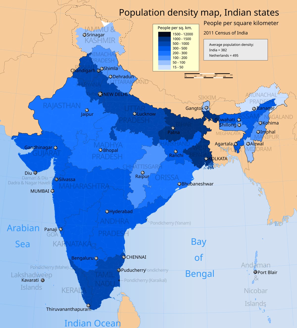
382
Bihar 1,106 (state); Delhi 11,320
Arunachal Pradesh 17
Sex ratio (women per 1000 men)
943
Kerala 1084; Puducherry 1037 (UT)
Haryana 879 (state); Daman & Diu 618 (UT)
Literacy rate
74.04%
Kerala, about 94%
Bihar, below 65%
Growth, 2001–2011
About 17.7%
—
—
Always say 'Census 2011' with these numbers. Delhi (868) has a lower sex ratio than Haryana, but Delhi is a UT, not a state. Literacy 74.04% is the figure most books use; the final tables give about 73%.
Population density by state, Census 2011 (state lines as in 2011). Darker blue = more people per km². The Ganga plains and Kerala are crowded; the hilly north-east is not. India's average was 382. Image: M Tracy Hunter, Wikimedia Commons · CC BY-SA 3.0
Religion (Census 2011)
People
Share
Hindus
96.63 crore
79.8%
Muslims
17.22 crore
14.2%
Christians (third)
2.78 crore
2.3%
Sikhs
2.08 crore
1.7%
Buddhists
0.84 crore
0.7%
Jains
0.45 crore
0.4%
Religion data of Census 2011. Among the states, Himachal Pradesh has the highest Hindu share (about 95%). Punjab's own Census 2011 figures — 2.77 crore people, sex ratio 895 — are on the Punjab pages.
QUICK CHECK
PYQ · Punjab Police SI 2023 — On the basis of the Census of India 2011, match the following: 1. Kerala, 2. Puducherry, 3. Delhi, 4. Haryana — with women per 1000 men: a. 1037, b. 1084, c. 879, d. 868.
Tap an option to answer
Answer: A — 1-b, 2-a, 3-d, 4-c
Kerala 1084 (b), Puducherry 1037 (a), Delhi 868 (d), Haryana 879 (c). The trap option swaps Delhi and Haryana: Delhi is even lower.
QUICK CHECK
PYQ · PPSC OHE 2016 — According to the Census of India 2011 which state has the least number of females for every 1000 males?
Tap an option to answer
Answer: B — Haryana
Haryana had 879, the lowest of all states. Jammu & Kashmir (then a state) had 889, Sikkim 890 and Punjab 895.
QUICK CHECK
PYQ · Punjab Police SI 2023 — As per Census of India 2011, which of the following is the third largest religious community in India, with 2.78 crore people?
Tap an option to answer
Answer: B — Christians
Hindus, Muslims, then Christians (2.78 crore, 2.3%). Sikhs come fourth with 2.08 crore.
QUICK CHECK
PYQ · Punjab Police SI 2023 — According to the 2011 Census, which of the following Indian states has the highest percentage of Hindu population?
Tap an option to answer
Answer: C — Himachal Pradesh
Himachal Pradesh: about 95% Hindu. Chhattisgarh (about 93%) is next among these options; Madhya Pradesh and Gujarat are lower.
How India's population grew
Rule in one line: population grows fast when the death rate falls but the birth rate stays high.
FOUR PHASES OF GROWTH (NCERT)
1
1901–1921: stagnant
Famines, plague and the 1918 flu kept deaths high. In 1911–21 the population even fell.
↓
2
1921–1951: steady growth
Better health and sanitation; the death rate fell. 1921 is called the year of the 'great divide'.
↓
3
1951–1981: population explosion
Deaths fell fast but births stayed high.
↓
4
1981–2011: high but slowing
The birth rate began to fall; growth in 2001–11 was about 17.7%.
KEY TERM
Crude birth rate and death rate
Crude birth rate = live births in a year for every 1000 people. Crude death rate = deaths in a year for every 1000 people. Growth = birth rate minus death rate (plus migration).
Births per 1000→minus deaths per 1000→= natural growth
QUICK FACT
India's first census was in 1872; the first one held all over India at the same time was in 1881. Since then it is held every ten years. The 2011 census was the 15th, and the 7th after independence.
QUICK CHECK
PYQ · Punjab Police SI 2023 — In the decades 1921-1951, India saw steady population growth and, because of improvements in health and sanitation, the death rate _______.
Tap an option to answer
Answer: A — decreased
Better health care and sanitation cut deaths. With births still high, the population grew steadily.
QUICK CHECK
PYQ · PSSSB Patwari 2021 — Live births per 1000 population per year is called:
Tap an option to answer
Answer: C — Crude birth rate
It is the crude birth rate — 'crude' because it counts the whole population, not only women of child-bearing age.
Neighbours and border states
Rule in one line: seven countries touch India by land; Sri Lanka and Maldives lie across the sea.
India's land borders
Bangladesh
4,096.7 km
China
3,488 km
Pakistan
3,323 km
Nepal
1,751 km
Myanmar
1,643 km
Bhutan
699 km
Afghanistan
106 km
Lengths as given by the Ministry of Home Affairs. Bangladesh has the longest border; Afghanistan the shortest (in the Gilgit-Baltistan area of Ladakh, as shown on India's official map).
Uttarakhand, Uttar Pradesh, Bihar, West Bengal, Sikkim
Myanmar
Arunachal, Nagaland, Manipur, Mizoram
Bhutan
Sikkim, West Bengal, Assam, Arunachal
Sikkim touches three countries: Nepal, China and Bhutan. Arunachal touches Bhutan, China and Myanmar. Manipur touches Myanmar, not Bangladesh.
QUICK FACT
India lies wholly in the Northern and Eastern hemispheres: north of the Equator and east of the Prime Meridian. The mainland stretches from about 8°4'N to 37°6'N and from 68°7'E to 97°25'E (NCERT).
1947
Radcliffe Line
India–Pakistan (and today's India–Bangladesh) border, drawn by Cyril Radcliffe at Partition.
1914
McMahon Line
India–China line in the east, along Arunachal Pradesh.
1893
Durand Line
Pakistan–Afghanistan line. Not an Indian border today.
Three named lines that papers mix up.
Country
Capital
Main language
Afghanistan
Kabul
Pashto, Dari
Pakistan
Islamabad
Urdu
China
Beijing
Mandarin
Nepal
Kathmandu
Nepali
Bhutan
Thimphu
Dzongkha
Bangladesh
Dhaka
Bengali (Bangla)
Myanmar
Naypyidaw
Burmese
Sri Lanka
Sri Jayawardenepura Kotte (Colombo: main city)
Sinhala, Tamil
Maldives
Malé
Dhivehi
Neighbours, roughly from north to south. The Maldives is the smallest: its 2014 census counted about 0.40 million people (about 4 lakh). China adopted its one-child policy in 1980; it was relaxed to two children from 2016.
QUICK CHECK
PYQ · Punjab Police SI 2016 — Which Indian State has borders with three countries namely Nepal, Bhutan and China?
Tap an option to answer
Answer: D — Sikkim
Sikkim: Nepal to the west, China to the north and east, Bhutan to the south-east. Arunachal touches Myanmar, not Nepal.
QUICK CHECK
PYQ · RSMSSB LDC 2024 — Which one of the following Indian states does not share its state boundary with Bangladesh?
Tap an option to answer
Answer: B — Manipur
The five Bangladesh-border states are West Bengal, Assam, Meghalaya, Tripura and Mizoram. Manipur borders Myanmar.
QUICK CHECK
PYQ · Punjab Police SI 2023 — What is the length of the border between India and Bhutan?
Tap an option to answer
Answer: C — 699 km
699 km (Ministry of Home Affairs). It runs along Sikkim, West Bengal, Assam and Arunachal Pradesh.
QUICK CHECK
PYQ · PPSC OHE 2016 — The Radcliffe line is a boundary between:
Tap an option to answer
Answer: A — India and Pakistan
India and Pakistan (1947). PPSC APRO 2016 asked the same. The McMahon Line is with China; the Durand Line is Pakistan–Afghanistan.
QUICK CHECK
PYQ · Punjab Police SI 2023 — Identify the correct sequence from North to South of the following neighbouring countries of India.
Tap an option to answer
Answer: B — Afghanistan < Nepal < Bangladesh < Sri Lanka
Afghanistan is farthest north, Nepal along the Himalaya, Bangladesh further south, and Sri Lanka far south. The Maldives would be last of all.
QUICK CHECK
PYQ · Punjab Police SI 2023 — Dhivehi is the official language of which of the following neighbouring countries of India?
Tap an option to answer
Answer: C — Maldives
Dhivehi is the language of the Maldives. Sri Lanka uses Sinhala and Tamil; Bhutan uses Dzongkha; Nepal uses Nepali.
Traps and practice
Last revision — where the options try to fool you.
COMMON TRAPS
Kavaratti is Lakshadweep's capital. Port Blair (now Sri Vijaya Puram) is the Andaman & Nicobar capital.
Lowest sex ratio among states = Haryana (879). Delhi (868) and Daman & Diu (618) are lower, but they are UTs.
Third largest religious group = Christians (2.78 crore), not Sikhs (2.08 crore).
Three countries Nepal–Bhutan–China = Sikkim. Arunachal's three are Bhutan–China–Myanmar.
India–Bhutan border = 699 km. Do not confuse with 669 or 696.
States today: 28; UTs today: 8. Old books say 29 states and 7 UTs.
CHECK YOURSELF
Why did India's population grow fast after 1951 even though families did not become larger?
Show answer
Medicines, vaccines and clean water cut the death rate sharply. The birth rate stayed high for a long time, so the gap between births and deaths — the growth — became very large.
FLASHCARDS
States and census flashcards
Capital of Lakshadweep
Kavaratti
Capital of Mizoram
Aizawl
Capital of Dadra & Nagar Haveli and Daman & Diu
Daman
Newest state
Telangana, 2 June 2014
Largest state by area
Rajasthan
Smallest state by area
Goa
Highest sex ratio (Census 2011)
Kerala, 1084
Densest state (Census 2011)
Bihar, 1,106 per km²
Longest land border
Bangladesh
Official language of the Maldives
Dhivehi
QUICK BYTES
28 states, 8 UTs; Chandigarh is shared by Punjab and Haryana
1956 language-based reorganisation; Telangana 2014; J&K and Ladakh UTs 2019
Rajasthan largest, Goa smallest by area; UP most, Sikkim fewest people
Census 2011: 121.09 crore, density 382, sex ratio 943, literacy 74.04%
1921–51 death rate fell; crude birth rate = births per 1000 a year
Borders: Bangladesh longest, Afghanistan shortest, Bhutan 699 km
❧
Frequently Asked Questions
How many states and union territories does India have?
28 states and 8 union territories. The count changed in 2019, when Jammu & Kashmir became two UTs, and in 2020, when two western UTs merged.
What is the capital of Lakshadweep?
Kavaratti. Lakshadweep is a group of 36 coral islands in the Arabian Sea and is India's smallest UT.
What is the capital of Andhra Pradesh?
Amaravati is the declared capital and is still being built. Hyderabad, now Telangana's capital, was the shared capital until June 2024.
Which is the newest state of India?
Telangana, formed on 2 June 2014 as the 29th state. After 2019 India has 28 states, because Jammu & Kashmir became a UT.
Which is the largest state by area and by population?
By area, Rajasthan. By population, Uttar Pradesh (about 19.98 crore in Census 2011). Goa is the smallest by area and Sikkim has the fewest people.
What was India's sex ratio in Census 2011?
943 women for every 1000 men. Kerala was highest (1084) and Haryana lowest among states (879).
What were India's population density and literacy in Census 2011?
Density was 382 people per km², highest in Bihar among states. Literacy was 74.04% in the figure most books use, highest in Kerala.
Which countries share a land border with India?
Seven: Bangladesh, China, Pakistan, Nepal, Myanmar, Bhutan and Afghanistan. The border with Bangladesh is the longest. Sri Lanka and the Maldives are sea neighbours.
Which Indian state borders Nepal, Bhutan and China?
Sikkim. Its most spoken language is Nepali and its capital is Gangtok.
What is the Radcliffe Line?
The border between India and Pakistan drawn by Cyril Radcliffe at Partition in 1947. Its eastern part is now the India–Bangladesh border.