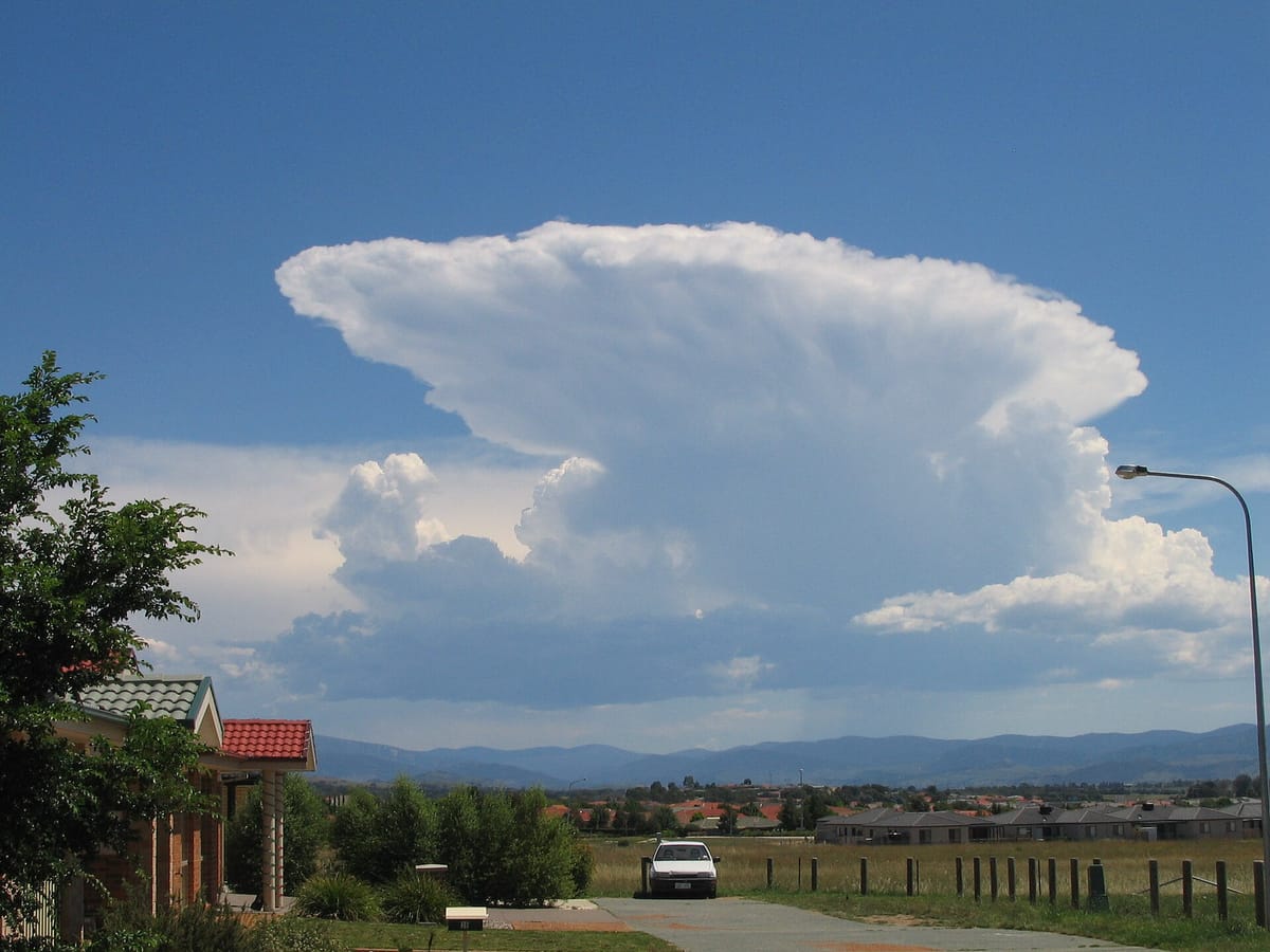
Weather is what the air is doing today: hot or cold, wet or dry, calm or stormy. It is driven by the Sun's heat, which warms the land, the sea and the air unevenly. Uneven heat makes pressure differences, pressure makes winds, and winds carry moisture that falls as rain. The oceans store heat and move it round the world in currents.
On this page you will learn:
- What air is made of, and how temperature changes in each layer
- Insolation, albedo, the heat budget and temperature inversion
- Pressure belts, planetary winds, jet streams and El Niño
- Humidity, clouds, rain and cyclones
- Ocean trenches and salinity
- Currents, tides and tsunamis
- Coral reefs, atolls, lagoons and island groups
The air and its layers
Rule in one line: temperature falls, rises, falls and rises again as you go up through the four lower layers.
Dry air is about 78% nitrogen, 21% oxygen and almost 1% argon; carbon dioxide is only about 0.04% but traps heat. Water vapour and dust are found mostly in the lowest layer. The order of the layers is on the World Geography page; here we look at how each one behaves.
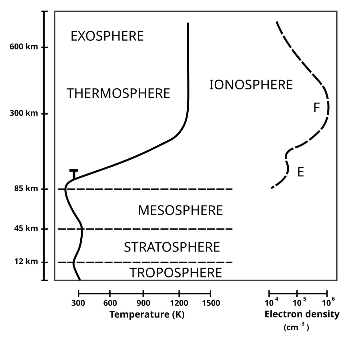
| Layer | Temperature with height | Why it matters |
|---|---|---|
| Troposphere | Falls about 1°C every 165 m | All weather; about 8 km thick at the poles, 18 km at the Equator |
| Tropopause | Stays the same | An isothermal (same-temperature) boundary |
| Stratosphere | Rises | Ozone absorbs the Sun's ultraviolet rays |
| Mesosphere | Falls, to about −100°C at 80 km | Coldest part of the atmosphere |
| Thermosphere (with ionosphere) | Rises fast | Charged layers reflect radio waves back to Earth |
The amount of ozone above a place is given in Dobson units — they measure the thickness of ozone in a column of air.
The Sun's heat and temperature
Rule in one line: the Sun heats the ground first, and the ground heats the air from below.
Insolation is incoming solar radiation, in short waves. Out of every 100 units reaching the top of the atmosphere, about 35 are reflected straight back to space — this share is the Earth's albedo. The other 65 are absorbed (14 by the air, 51 by the surface). The Earth sends the same 65 back as long-wave heat, so its average temperature stays steady.
Fresh snow reflects the most sunlight — often over 80%. A snow covered field stays cold even in bright sun. Sand reflects less, grass and crops less still, and dark forests, dark roofs and the sea absorb most of the light.
Normally air gets colder as you go up. In an inversion it gets warmer with height for a while. It happens on long, clear, calm winter nights: the ground loses heat fast and chills the air touching it. Cold heavy air also slides down into valleys. Smoke and moisture are trapped near the ground, giving fog and smog.
Pressure belts, winds and El Niño
Rule in one line: wind blows from high pressure to low pressure, and the Earth's spin bends it.
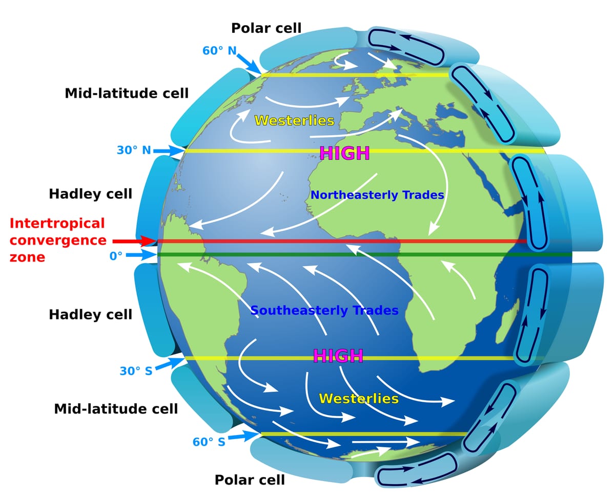
| Pressure belt | Latitude | Note |
|---|---|---|
| Equatorial low | Near 0° | Calm, rising air: the doldrums |
| Subtropical high | About 30° N and S | Sinking dry air: the horse latitudes; most hot deserts |
| Subpolar low | About 60° N and S | Westerlies meet polar air; stormy |
| Polar high | 90° N and S | Very cold, heavy air |
Narrow belts of very fast westerly wind near the top of the troposphere, roughly 9–12 km up. In winter the subtropical westerly jet flows south of the Himalaya over north India; its move north in early summer is linked with the onset of the monsoon.
Humidity, clouds, rain and cyclones
Rule in one line: cool moist air to its dew point and the vapour turns into dew, fog or cloud.
Absolute humidity is the actual amount of water vapour in the air. Relative humidity is that amount as a percentage of what the air could hold at that temperature. At 100% the air is saturated; the temperature at which this happens is the dew point. Humidity is measured with a hygrometer (the wet-and-dry-bulb kind is called a psychrometer).
| Level | Clouds | Look and weather |
|---|---|---|
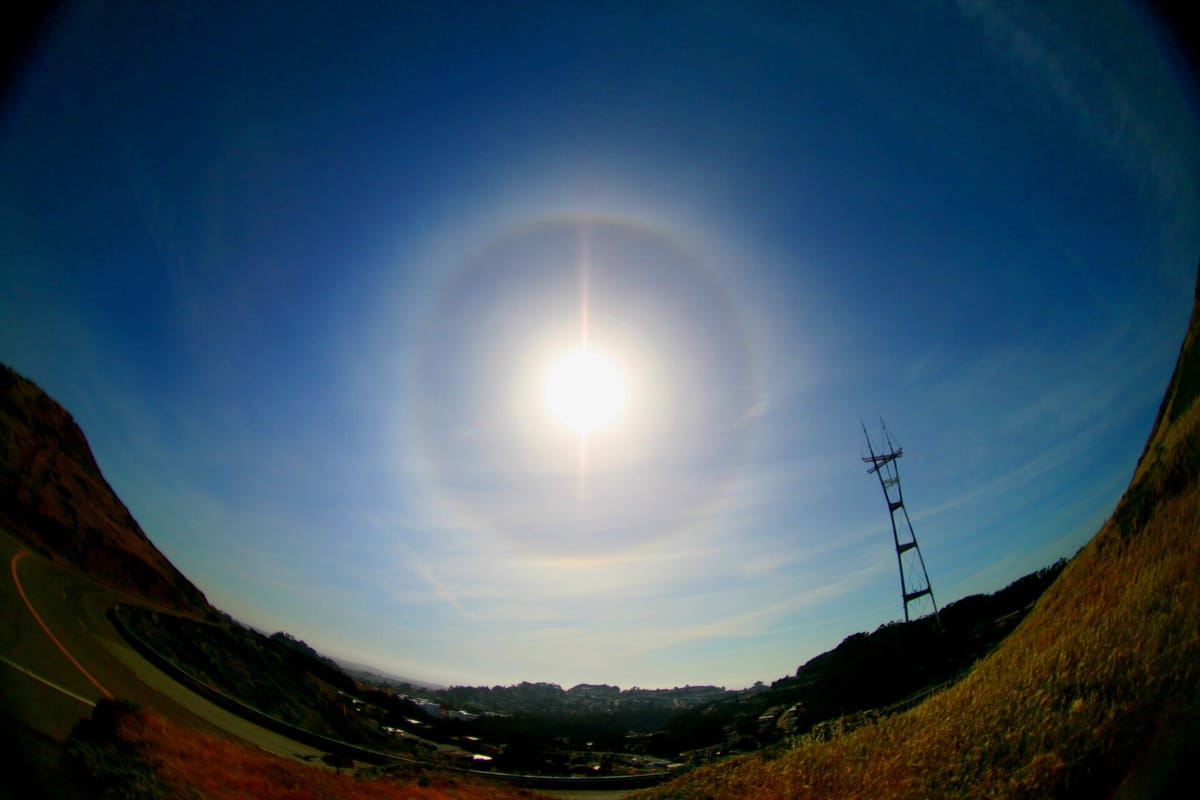
| High (above about 6 km) | Cirrus, cirrostratus, cirrocumulus | Thin, white, made of ice crystals; cirrostratus makes halos |
| Middle | Altostratus, altocumulus, nimbostratus | Grey sheets or rolls; nimbostratus is a thick, dark layer (its base often sinks low) that gives steady rain |
| Low | Stratus, stratocumulus | Grey, low layers or lumps; drizzle at most |
| Tall (vertical) | Cumulus, cumulonimbus | Cotton-wool heaps; cumulonimbus brings thunder, lightning and hail |
Hot ground makes moist air rise fast; afternoon thunderstorms near the Equator.
Wind is forced up a mountain: heavy rain on the windward side, a dry rain-shadow beyond.
Warm air slides up over cold air where two air masses meet.
Three kinds of rainfall. Precipitation can fall as rain, snow, sleet or hail.
| Region | Local name of a tropical cyclone |
|---|---|
| Indian Ocean (Bay of Bengal, Arabian Sea) | Cyclone |
| Atlantic, Caribbean, east Pacific | Hurricane |
| West Pacific, China Sea | Typhoon |
| North-west Australia | Willy-willy (older name) |
Ocean trenches and salinity
Rule in one line: the deepest trenches ring the Pacific; average sea water holds 35 parts of salt per thousand.
From the coast the sea floor goes: continental shelf, continental slope, deep-sea plain and ocean deeps (see the World Geography page). The deeps, or trenches, are long narrow troughs where one plate sinks under another.
| Trench | Ocean |
|---|---|
| Mariana (deepest, about 11 km) | Pacific |
| Tonga | Pacific |
| Java (Sunda) | Indian |
| Puerto Rico (deepest in the Atlantic) | Atlantic |
| Romanche | Atlantic |
The amount of salt dissolved in sea water, written in parts per thousand (‰). The average is 35‰. It is higher where evaporation is strong and little fresh water comes in (the Red Sea), and lower where big rivers and melting ice add fresh water (the Baltic Sea). Some inland lakes with no outlet are far saltier: the Dead Sea holds about 340 grams of salt per litre, nearly ten times the ocean. NCERT also lists Lake Van in Turkey among very salty lakes.
Currents, tides and tsunamis
Rule in one line: currents are rivers in the sea; tides are the daily rise and fall pulled by the Moon and Sun.
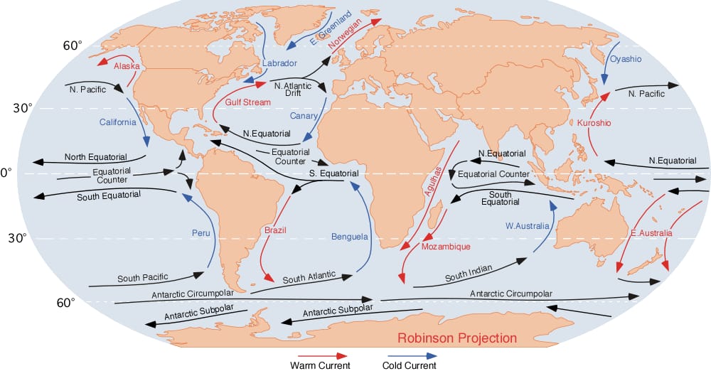
This warm current starts in the Gulf of Mexico and the Caribbean, runs up the east coast of North America and crosses the Atlantic as the North Atlantic Drift. It keeps north-west Europe mild and the ports of Norway free of ice. Where it meets the cold Labrador Current off Newfoundland, there is thick fog and rich fishing.
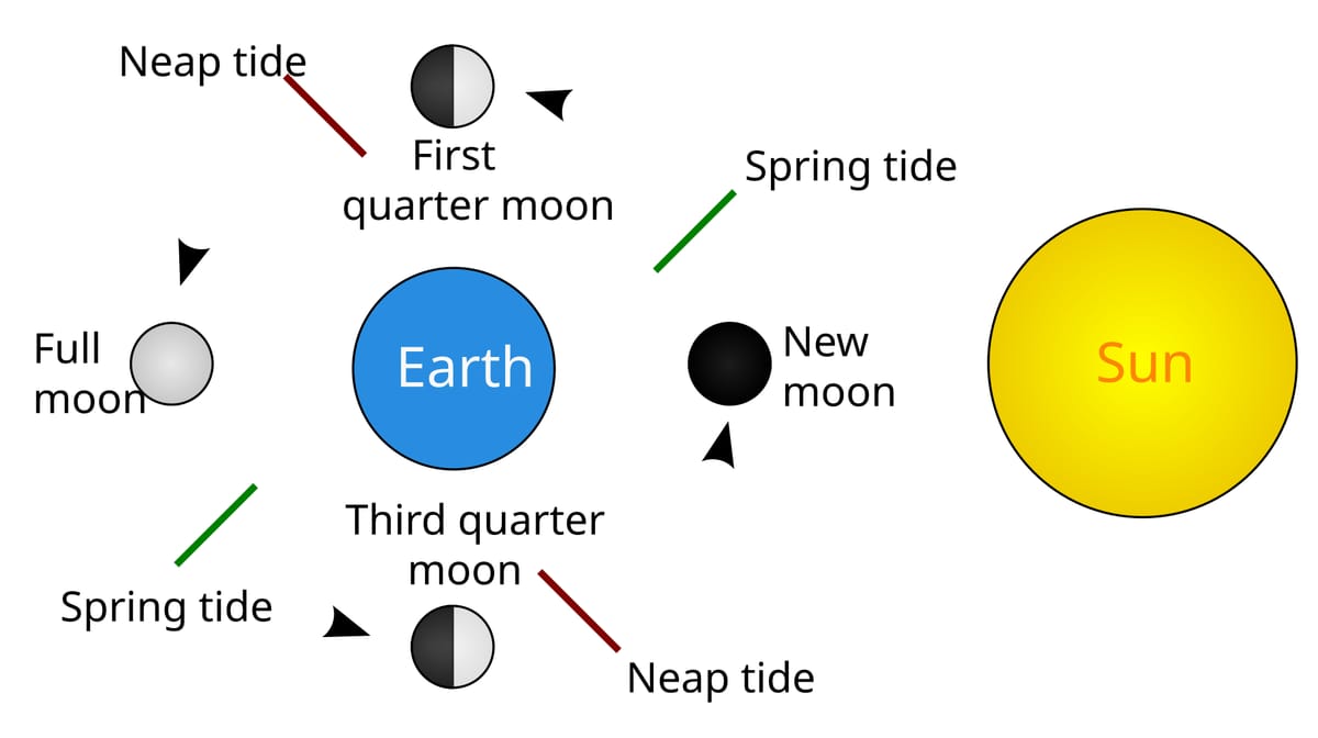
- Most coasts get two high tides and two low tides a day; high tide returns about every 12 hours 25 minutes.
- The Moon's pull matters more than the Sun's, because the Moon is much closer.
- The world's highest tides are in the Bay of Fundy in Canada. In India the largest tidal-power potential lies in Gulf of Cambay (Khambhat), then the Gulf of Kutch — both in Gujarat.
A Japanese word meaning 'harbour wave'. An undersea earthquake, volcano or landslide shoves a huge mass of water. Out at sea the wave is low but very fast; near the coast it slows down and rises into a wall of water. On 26 December 2004 a great earthquake off Sumatra sent a tsunami across the Indian Ocean that struck Indonesia, Sri Lanka, India and Thailand.
Coral reefs, atolls, lagoons and island groups
Rule in one line: coral reefs are built by tiny animals in warm, clear, shallow seas.
A coral is a tiny soft animal (a polyp) that builds a hard lime skeleton. Millions of them make a reef. Tiny algae live inside the polyps: the algae make food by photosynthesis and share it, and the coral gives them shelter. Both gain, so this is mutualism. If the sea gets too warm, corals push the algae out and turn white — coral bleaching.
Grows right next to the coast. Seen round parts of the Andaman Islands.
Separated from the coast by a wide lagoon. The Great Barrier Reef off Australia is the largest.
A ring of coral round a lagoon, with no island in the middle. Lakshadweep is made of coral atolls.
Three kinds of coral reef. Lakshadweep is a group of 36 islands; its capital is Kavaratti.
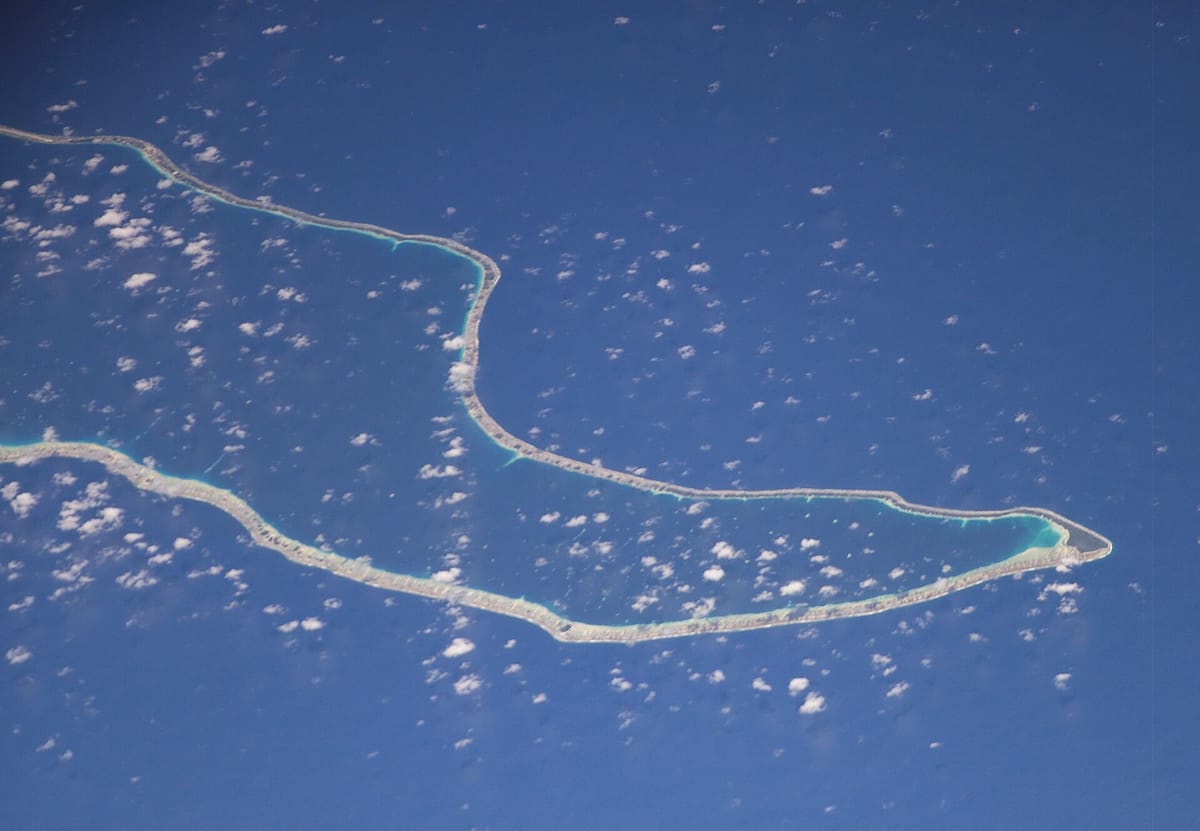
A lagoon is shallow salty or brackish water cut off from the sea by a sandbar or reef. Chilika in Odisha is the largest brackish-water lagoon in Asia; Pulicat on the Andhra–Tamil Nadu border is the next big one in India. An archipelago is a group or chain of islands, such as the British Isles, Indonesia, Japan, and the Andaman and Nicobar Islands.
Traps and practice
Last revision — where the options try to fool you.
- Temperature rises with height in the stratosphere — it does not fall in every layer.
- Inversion = temperature increases with height.
- Fresh snow reflects most; the daily range is biggest inland, not on coasts.
- Hygrometer = humidity; barometer = pressure; altimeter = height.
- Halo = cirrostratus; thunderstorm and hail = cumulonimbus.
- Puerto Rico Trench is in the Atlantic; Java Trench in the Indian Ocean.
- Spring tides come at new and full moon, not in the spring season.
- The 2004 tsunami was on 26 December, not 25.
A city on the coast and a city deep inland are at the same latitude. Which one has the bigger gap between day and night temperatures, and why?
Show answer
The inland city. Land heats and cools quickly, while the sea warms and cools slowly and keeps the coastal city's temperature even.
- Coldest layer of the atmosphere
- Top of the mesosphere
- Layer that reflects radio waves
- Ionosphere
- Unit for ozone thickness
- Dobson unit
- Surface with the highest albedo
- Fresh snow
- Calm belt at the Equator
- Doldrums
- Instrument for humidity
- Hygrometer
- Tropical cyclone in the west Pacific
- Typhoon
- Average salinity of the oceans
- 35‰
- Tides at new and full moon
- Spring tides
- Asia's largest brackish-water lagoon
- Chilika, Odisha
- Air: 78% nitrogen, 21% oxygen, almost 1% argon
- Temperature: falls (troposphere), rises (stratosphere), falls (mesosphere), rises (thermosphere)
- Earth's albedo about 35 out of 100 units; fresh snow reflects most
- Winds bend right in the north, left in the south (Coriolis)
- El Niño: warm sea off Peru, often a weak Indian monsoon
- Cyclone, hurricane, typhoon, willy-willy: one storm, four regions
- Gulf Stream warm, Labrador cold; spring tides at new and full moon
- Tsunami 26 December 2004; Lakshadweep = coral atolls; Chilika = lagoon