World geography starts with the Earth itself: how it spins and moves round the Sun, and the lines we draw on it to fix places and time. Then come the continents and oceans, the seas and straits between them, the air above, and the rocks below that cause earthquakes. Exams also ask a few country facts.
On this page you will learn:
- Rotation, revolution and why we have seasons
- Latitudes, longitudes, IST and the International Date Line
- Continents, oceans and world records
- Seas, straits and canals
- Layers of the atmosphere, winds and ocean currents
- Plates, earthquakes and volcanoes
- Neighbours' languages and currencies
Earth's motions and the seasons
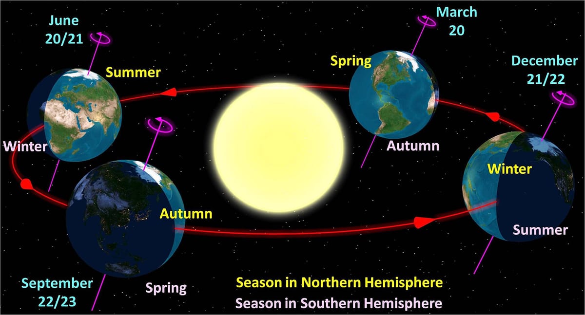
Rule in one line: rotation gives day and night; revolution with a tilted axis gives the seasons.
| Date | Event | Sun overhead at |
|---|---|---|
| 21 June | Summer solstice: longest day in the north | Tropic of Cancer |
| 22 December | Winter solstice: shortest day in the north | Tropic of Capricorn |
| 21 March, 23 September | Equinoxes: day = night everywhere | Equator |
Latitudes and longitudes
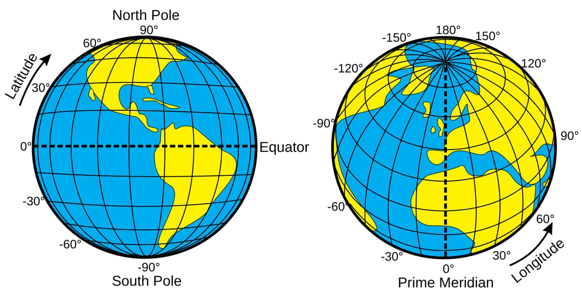
Rule in one line: latitudes run east–west and tell how far north or south; longitudes run pole to pole and tell time.
| Line | Latitude |
|---|---|
| North Pole | 90°N |
| Arctic Circle | 66½°N |
| Tropic of Cancer | 23½°N |
| Equator | 0° |
| Tropic of Capricorn | 23½°S |
| Antarctic Circle | 66½°S |
| South Pole | 90°S |
A circle on the globe whose centre is the centre of the Earth. The shortest route between two places runs along a great circle; that is why long flights curve over the poles on a flat map. The Equator is the only parallel that is a great circle; every pair of opposite meridians makes one.
The Tropic of Cancer crosses India through 8 states (Gujarat to Mizoram). Outside India it passes through Bangladesh, Myanmar, China, Oman, the UAE, Saudi Arabia, Egypt, Libya and on to Mexico — but not through Sri Lanka, Afghanistan or the Philippines.
Longitude and time
Rule in one line: 15° of longitude = 1 hour; places to the east are ahead in time.
The Earth turns 360° in 24 hours: 15° each hour, or 1° every 4 minutes. India's standard meridian is 82°30'E (82.5°E), which passes near Mirzapur in Uttar Pradesh. 82.5 × 4 = 330 minutes, so IST is 5 hours 30 minutes ahead of GMT.
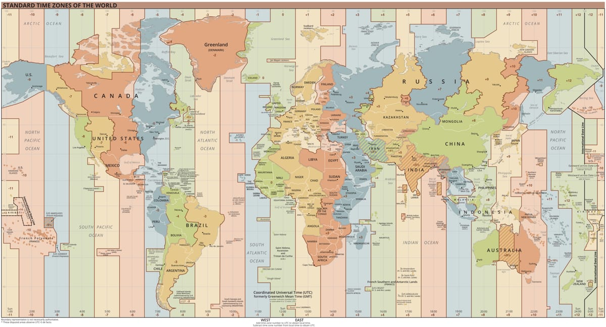
Passes through Greenwich, London. Its time is GMT (now called UTC).
Roughly along 180°, bent to avoid land. Cross it going west: add a day. Going east: go back a day.
Places on one meridian share the same time and date, however far apart north to south.
A globe has 360 degrees of longitude: 180 east and 180 west of Greenwich.
Continents, oceans and world records
Rule in one line: Asia is first in both land and people; Australia is the smallest continent, the Pacific the largest ocean.
| Rank | By area | By population |
|---|---|---|
| 1 | Asia | Asia |
| 2 | Africa | Africa |
| 3 | North America | Europe |
| 4 | South America | North America |
| 5 | Antarctica | South America |
| 6 | Europe | Australia (Oceania) |
| 7 | Australia | Antarctica (no permanent people) |
Largest and deepest; about a third of the Earth's surface. Holds the Mariana Trench.
S-shaped; the busiest for sea trade.
The only ocean named after a country. Mauritius and Christmas Island lie in it.
The Southern Ocean rings Antarctica; the Arctic is the smallest and shallowest.
The five oceans, largest first.
- 1Continental shelfShallow edge of the land under the sea
- 2Continental slopeSteep drop to the deep ocean
- 3Deep-sea plainFlat, wide ocean floor
- 4Ocean deeps (trenches)The deepest parts, e.g. the Mariana Trench
| Record | Answer | Note |
|---|---|---|
| Highest mountain | Mount Everest | 8,849 m; Nepal–China |
| Deepest point | Mariana Trench (Challenger Deep) | About 11 km deep; Pacific |
| Longest river | Nile (Africa) | Some studies rank the Amazon longer |
| Most water in a river | Amazon (South America) | Largest river basin too |
| Largest hot desert | Sahara (Africa) | Antarctica is the largest cold desert |
| Largest lake | Caspian Sea (salt water) | Largest freshwater lake: Superior |
| Deepest lake | Baikal (Russia) | — |
| Largest island | Greenland | Belongs to Denmark |
| Largest / smallest country | Russia / Vatican City | By area |
Seas, straits and canals
Rule in one line: a strait is a narrow natural sea passage between two lands; a canal is dug by people.
| Passage | Between | Joins |
|---|---|---|
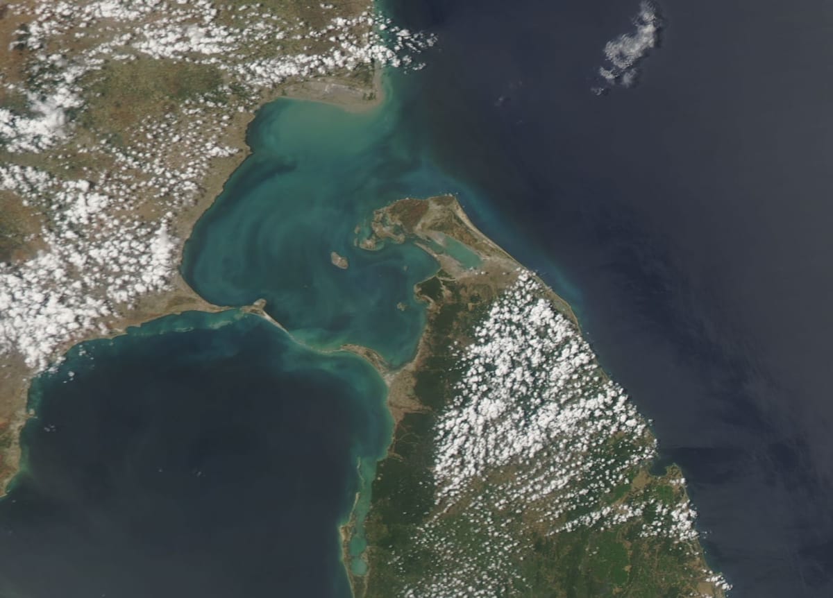
| Palk Strait | India – Sri Lanka | Bay of Bengal – Palk Bay |
| Strait of Malacca | Malaysia – Sumatra (Indonesia) | Indian Ocean – South China Sea |
| Strait of Hormuz | Iran – Oman | Persian Gulf – Gulf of Oman |
| Strait of Gibraltar | Spain – Morocco | Atlantic – Mediterranean |
| Bering Strait | Russia – Alaska (USA) | Pacific – Arctic |
| Bosporus | Europe – Asia, in Turkey | Black Sea – Sea of Marmara |
| Suez Canal (1869) | Egypt | Mediterranean – Red Sea |
| Panama Canal (1914) | Panama | Atlantic – Pacific |
More places asked onceTap to open
- The Caspian Sea is bordered by Kazakhstan, Russia, Azerbaijan, Iran and Turkmenistan. It is the world's largest lake.
- Sumatra is Indonesia's westernmost large island; Java, Bali and Lombok lie further east.
- Japan's four main islands, north to south: Hokkaido, Honshu, Shikoku, Kyushu.
- China has island disputes with the Philippines and Vietnam in the South China Sea. The uninhabited Senkaku (Diaoyu) islands in the East China Sea are disputed by China and Japan.
- An archipelago is a group of islands. The British Isles (Great Britain, Ireland and many small islands) form one; Sri Lanka, Madagascar and Tasmania are single large islands.
- Cities on rivers: Niger – Niamey, Danube – Budapest (also Vienna and Belgrade), Congo – Kinshasa. Recife in Brazil is on the Atlantic coast, so Amazon - Recife is a wrong pair; Manaus lies on the Amazon.
- Largest freshwater lakes by volume of water: Baikal – Tanganyika – Superior – Malawi. By surface area, Superior is the largest freshwater lake.
- Angkor Wat, the largest religious monument in the world, is in Cambodia. The burning Darvaza gas crater ('Gateway to Hell') is in Turkmenistan.
- Cuba is called the 'sugar bowl of the world'.
The atmosphere, winds and ocean currents
Rule in one line: weather happens in the lowest layer; winds and currents carry heat from the tropics towards the poles.
| Layer (lowest first) | Height | Remember |
|---|---|---|
| Troposphere | About 13 km on average | All weather; almost all water vapour and dust |
| Stratosphere | Up to about 50 km | Ozone layer; calm air, good for jet aircraft |
| Mesosphere | Up to about 80 km | Meteors burn up here |
| Thermosphere | About 80–400 km | Ionosphere reflects radio waves; heat rises with height |
| Exosphere | Above that | Very thin air fading into space |
Upwards: Tall Strong Men Take Exercise — Troposphere, Stratosphere, Mesosphere, Thermosphere, Exosphere.
| Local wind | Hot or cold | Where |
|---|---|---|
| Sirocco | Hot, dry, dusty | From the Sahara across the Mediterranean to Italy |
| Loo | Hot, dry | North Indian plains in May–June |
| Harmattan | Dry, dusty | West Africa; called 'the doctor' |
| Chinook / Foehn | Warm, dry | Rockies / Alps; melts snow |
| Mistral, Bora, Tramontana | Cold | France, the Adriatic coast, Spain–Italy |
Inside the Earth: plates, earthquakes and volcanoes
Rule in one line: the crust is broken into moving plates; most quakes and volcanoes happen where plates meet.
Thin outer shell: thicker under continents, thinner under oceans.
Thick hot rock layer; slowly flowing in its upper part.
Mostly iron and nickel; outer core liquid, inner core solid.
The three layers of the Earth, outside in.
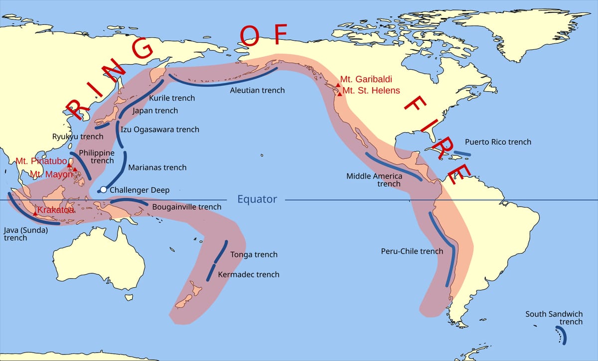
An earthquake starts at the focus (hypocentre), deep inside the Earth. The point on the surface just above the focus is the epicentre; shaking is usually strongest there. A seismograph records the waves, and the Richter scale gives the size (magnitude).
Countries: languages, currencies and people
Rule in one line: for neighbours, learn the language and the currency together.
| Country | Currency | Official language |
|---|---|---|
| Bangladesh | Taka | Bangla (Bengali) |
| Sri Lanka | Sri Lankan rupee | Sinhala and Tamil |
| China | Renminbi (yuan) | Mandarin Chinese |
| Nepal | Nepalese rupee | Nepali |
| Bhutan | Ngultrum | Dzongkha |
| Pakistan | Pakistani rupee | Urdu (and English) |
| Myanmar | Kyat | Burmese |
| Maldives | Rufiyaa | Dhivehi |
The Han people make up about 91–92% of China's population. Mandarin (Putonghua) is the official language; Wu, Hakka and Foochow are regional Chinese languages, not the official one.
Traps and practice
Last revision — where the options try to fool you.
- IST is +5:30; +5:45 is Nepal's time.
- Meridians come closer towards the poles; parallels stay the same distance apart.
- Smallest continents: Australia, then Europe — not Antarctica.
- Epicentre is on the surface; the focus is inside the Earth.
- Sirocco is hot (Sahara); Mistral and Bora are cold.
- Palk Strait and Gulf of Mannar both separate India from Sri Lanka.
- 'Increasing order' means smallest first — check before you tick.
It is 12 noon at Greenwich. What is the time at a place on 90°E?
Show answer
90 × 4 = 360 minutes = 6 hours. The place is east, so it is ahead: 12 noon + 6 hours = 6 pm.
- Time for 1° of longitude
- 4 minutes
- India's standard meridian
- 82°30'E, near Mirzapur
- 180° longitude
- International Date Line
- Shortest route on the globe
- Great circle
- Deepest point in the oceans
- Mariana Trench
- World's largest lake
- Caspian Sea
- Layer with the ozone
- Stratosphere
- Hot dusty wind from the Sahara
- Sirocco
- Oceanic plate sinking into the mantle
- Subduction
- Currency of Bangladesh
- Taka
- Rotation 24 h, west to east; revolution 365¼ days; axis tilt 23½°
- 21 June and 22 December solstices; 21 March and 23 September equinoxes
- 360 longitudes; 15° = 1 hour; IST 82.5°E = GMT + 5:30
- Asia largest; Australia and Europe smallest; Pacific largest ocean
- Everest 8,849 m; Mariana Trench about 11 km deep
- Troposphere → stratosphere → mesosphere → thermosphere → exosphere
- Subduction at convergent boundaries; epicentre above the focus